July 31, 2009

On July 30, the Museum updated its Google Earth initiative Crisis in Darfur with the latest U.S. Department of State data that sheds new light on the extent of the genocide in Darfur.
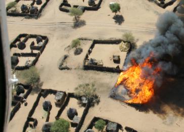
The new data shows that more than 3,300 villages have been damaged or destroyed, primarily between 2003-2005, in the Darfur region of Sudan. This is more than twice the number that was identified in previous U.S. government assessments and strengthens the evidence of a vast, targeted campaign of destruction against civilians.
This is the most detailed picture to date of the scope and nature of the destruction that occurred during the genocide in Darfur and after. That thousands of villages were destroyed has been known for some time; this data documents the true enormity of the destruction. The data also includes hundreds of "before and after" satellite images of villages throughout Darfur, as well as additional details about when the villages were destroyed. This data also confirms that most villages were destroyed between 2003 and 2005, during the height of the brutal Sudanese government-backed campaign targeting civilians in Darfur.
Stay tuned for additional features in Crisis in Darfur, including a narrated flyover tour and a map of destroyed villages by year.
To access the Crisis in Darfur layers in Google Earth, visit Mapping Initiatives: Crisis in Darfur.
Learn more about the current situation in Sudan; view the press release announcing the update; and read about it in The Washington Post (external link).
